866-412-1270
866-283-7796
Vill du snabbt och enkelt digitalisera dina skannade ritningar till korrekta DWG, DXF (DGN eller annat CAD format) f�r snabb och effektiv edering i CAD – utan att spendera en f�rm�genhet? Vi p� Design Presentation erbjuder dig digitalisering/ vektorisering, en robust och allt�ckande konvertering som �r anv�ndbar f�r varje professionell, kommersiell, industriell och vetenskaplig aktivitet.
Vektorisering �r den mest kraftfulla l�sningen f�r att digitalisera vektor data fr�n bilder.V�r konkurrensm�ssigt prissatta l�sning sparar pengar och avancerad prestanda sparar tid.
Det finns m�nga f�rdelar med Scan 2 CAD konvertering:
Skanna till CAD konvertering (Portf�ljexempel)
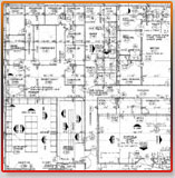
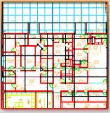
In order to digitize your raster images, we create a drawing as a new file; the final output is editable and will be in DXF, DWG or DGN format and can have as many layers as you require.
We provide highly accurate, cost-effective digitization services with a quick turn around even on large jobs.We offer the digitization of architectural, engineering, construction, and CAD or GIS files.
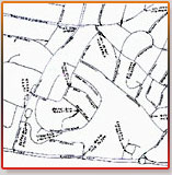
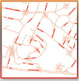
You can use digitization procedure to process charts, drawings, maps, schemes and other similar images. We offer both manual and automated (auto-vectorization) services. We offer a unique platform for industry-oriented solutions and have various tools to get a perfect set of vector data faster and easier. We offer architectural, civil, engineering, construction, electrical, mechanical CAD or GIS files, ready-to-use, created from raster images, maps, blueprints etc. We render prompt, error free, accurate, reliable and economical services to our clients.
The key advantages of Scan2CAD service include:
The converted drawings[ Scan2CAD] are manually drawn with precision and are fully editable and contains:
OUR WIDE RANGE OF FORMATS:
General:
Data Entry, Data Scrubbing, Digitization
AEC CAD:
File Conversion, Precision Redraw (manual vectorization), Tracing GIS: Data Attribution, DEM Data, Geo-referencing, Rubber-sheeting
Orthophoto:
Data Conflation, Feature Extraction, Orthophoto Rectification, Photo-grammetry
FORMATS SUPPORTED BY DESIGNPRESENTATION:
Images:
Design Presentation supports over 300 different image formats including IMG, JPEG, PCX, PDF, PICT, and TIFF
Media:
FTP, E-mail, CD-Rom, etc.
*Vector:
ARC, BNA, CDF, CGM, CLP, CPS3, DGI, DLIS, DWG, DXF, FINDER, IES, LAS, LDF, LIS, MIF, SEGP1, SHP, ZMAP, etc.
Our digitizing services will allow you to convert any logo or graphic to vector format. If you have an
old logo, graphic or artwork that is hand drawn or scanned, it can be digitized. All we need from you is a scan or copy of the image to be digitized, just clear enough to see details. Our ideal mix of quality, consistency and competitive prices has led to long term relationships with customers. Our large infrastructure and experience allows us to provide highest quality of CAD services at amazing low prices.
We guarantee 99.99% accuracy in the final output.
We use in-house software and techniques for de-speckling and de-skewing rasters. We use a heads-up manual redraw process for conversion to ensure dimensionally accurate CAD perfect output.
We have a large pool of Engineers and CAD Technicians that can produce high-end vectorized output from a raster format. The team is headed by qualified engineers with extensive experience in their respective areas of expertise. Our customers include the most prestigious names in engineering, large and small, throughout North America and Europe
.
We individually craft our imaging services to address each client’s specific needs, never force-fitting customers into a standardized framework. Having served a large number of clients worldwide, we are familiar with the detailing procedures that are seldom captured by any purely software-based solutions.